At one end, a town often associated with wealth and privilege. At the other, a once-thriving manufacturing city that has struggled to find its footing in the 21st century amidst struggles with poverty and crime. And in between, officials hope, a multimodal alternative to highways and railways that can literally and figuratively help bridge the gap between areas of economic distress and economic opportunity.
Officials from Mercer County and the Delaware Valley Regional Planning Commission (DVRPC) host an online information session on Wednesday, June 12, to inform officials, businesses, and the general public about the Johnson Trolley Trail Corridor Study. The study, funded by a $175,000 grant from the DVRPC, aims to connect existing trail segments in order to create a bicycle and pedestrian corridor between Trenton and Princeton, passing through Lawrence and Ewing townships.
To join the session, taking place via Zoom from 6 to 8 p.m., visit zoom.us/j/9930558649. Public comment will be accepted through Wednesday, July 10, by mail to Sophia Fox, Stokes Creative Group, 1666 Route 206, Vincentown, NJ 08088 or by email to sfox@stokescg.com.
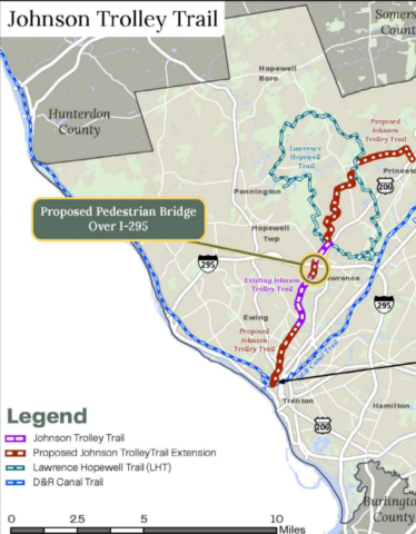
Currently, officials are assessing the feasibility of various concepts for connecting existing portions of the trail and will present those concepts at the information session. Three new segments are under consideration to supplement the existing “northern” and “southern” segments located in Lawrence Township. The northern segment is an unpaved trail; the southern segment is a mix of paved-shared use paths and trails that reaches into Ewing Township.
An additional information session will be scheduled for this fall. Completion of the feasibility/concept development phase is anticipated in winter 2025.
A page dedicated to the project on Mercer County’s website, www.mercercounty.org, states as the project’s goals “to link areas of high economic distress with areas of increasing economic opportunity, provide a safe alternative to traditional motor vehicle transportation, and connect high-density residential, commercial, and institutional areas with open space, parks, and recreational facilities.”
“This project would allow for safer off-road connections between residential, commercial and retail areas of Mercer County and connect numerous employment and educational institutions that would allow employees and students the ability to travel without requiring motorized transportation,” the website continues. “It would also connect disadvantaged communities to more employment centers, build in resiliency to our transportation network and could offer new economic development opportunities.”
The website goes on to explain the history of the Johnson Trolley Line and the potential positive impact of recreating the trail and offering a pedestrian link between Trenton and Princeton.
“The Johnson Trolley Trail is a trail that runs along the old right-of-way line of the former Trolley Rail Line. In the early half of the 20th century, the Trenton-Princeton Traction Company ran a trolley, known as the “Fast Line,” through this corridor. At the time a fare cost approximately 10¢ and a one-way trip between Princeton and Trenton took roughly 35 minutes, passing through vast farmland and what is now Olden Ave, Spruce Street, Eggerts Crossing Road, I-295, Lawrenceville Village, and the Municipality of Princeton.
“The Johnson Trolley began operating in 1902 and in its peak year of 1921 carried 1.6 million fares. The Johnson Trolley Line was purchased in 1929 by the Reading Railroad, which ran local freight service until 1973, when the new interstate cut off access to the line. [During World War II], passenger service was stopped and never returned. The Johnson Trolley Line Trail currently occupies only a portion of old right-of-way abandoned by the former trolley company.”
The continuous trail was cut off by the construction of Interstate 295 in the early 1970s, and the proposed project includes a pedestrian-bicycle bridge over I-295 as well as alternative routes for areas of the original trolley line that now fall on privately owned lands.
But, per the county webpage, these efforts are expected pay dividends for the communities along the trolley line.
“All four municipalities included in the study area (City of Trenton, Ewing and Lawrence Townships, and the Municipality of Princeton) are projected by DVRPC to experience positive population growth by 2050. However, in the same period, DVRPC projections show much faster employment growth relative to the population in the Municipality of Princeton (76%) and Lawrence Township (81%) than in the City of Trenton (66%) and Ewing Township (50%).
“This proposed Johnson Trolley Line Multi-Use Corridor project would create an important missing link and act as a spine linking other existing multimodal connectors. This spine would connect disadvantaged communities to additional employment opportunities, educational institutions, and local open space and parks, without requiring motor vehicles. Educational institutions within a mile of the proposed alignment include Princeton University, Princeton Theological Seminary, the Institute for Advanced Study, Rider University, The College of New Jersey, Lawrenceville School, Notre Dame High School, Hun School, Princeton International School of Mathematics and Science, as well as numerous elementary, intermediate, middle, and high schools.
“The two largest private employers in Mercer County are Princeton University and Bristol Myers Squibb. Recent and planned improvements in the Municipality of Princeton increase pedestrian and bicycle access to the University, while the two major Bristol Myers Squibb campuses connect directly to the existing off-road Lawrence Hopewell Trail (Circuit Trail). The proposed Johnson Trolley Trail corridor links these elements, opening access and opportunities for underserved populations in the study area.
And a reconnected trail is just the beginning of the project’s broader ambitions.
“With our partners, the goal of this effort is to create a long distance ‘trunk line’ from which additional trails, footpaths, sidepaths, bicycle lanes and sidewalks will ultimately be able to connect into,” the county website states. “Additionally, another goal of the project is to link areas of high economic distress with areas of increasing economic opportunity and to connect high density residential, commercial and institutional areas with preserved open space, parkland, and existing Circuit Trails.”
Furthermore, the site continues, “As the network develops, local businesses may be able to capitalize on the new trail network. A new trail user market may allow for new business opportunities catering to needs of trail users and the local economy may be able to capitalize on special events that could be organized along various routes.”